
Topic: Systems Thinking
Systems Thinking
Compared to a well-sorted sample of larger-sized particles, a well-sorted sample of smaller-sized particles has greater
(1) capillarity
(2) transpiration
(3) permeability
(4) porosity
The aerial photograph below shows small, circular bodies of water surrounded by sediment in an area that was once covered by glaciers.

These bodies of water are known as
(1) finger lakes
(2) kettle lakes
(3) tributaries
(4) watersheds
Southeast Asia Monsoons
The Southeast Asia monsoons are seasonal shifts in the direction of regional planetary winds. These shifts are related to the movement of air pressure belts as the Sun’s vertical ray changes latitude. In the late spring, winds begin to blow from the southwest, bringing moisture from the Gulf of Thailand across Southeast Asia. Rainfall reaches a peak in July and August. This moisture is partially blocked by the Annamite Mountains, located along the border between Vietnam and Laos. Therefore, the rainfall in central Vietnam is somewhat less during these months. In September, the winds reverse direction and begin to flow from the northeast across the Gulf of Tonkin and South China Sea. This wind shift begins the season of heavy rainfall in central Vietnam that continues for months.
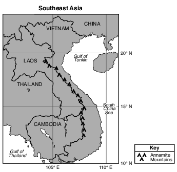
Heavy rains occur in Cambodia and Thailand when the moist air brought by the monsoon
(1) rises, expands, and cools
(2) rises, contracts, and warms
(3) sinks, expands, and cools
(4) sinks, contracts, and warms
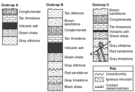
Which processes formed the unconformities shown in outcrops B and C?
(1) folding, faulting, and tilting
(2) uplift, erosion, and deposition
(3) weathering, abrasion, and igneous intrusion
(4) melting, contact metamorphism, and solidification
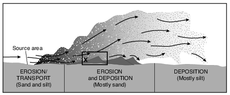
Which agent of erosion moves the particles within this erosional-depositional system?
(1) waves
(2) wind
(3) running water
(4) moving ice
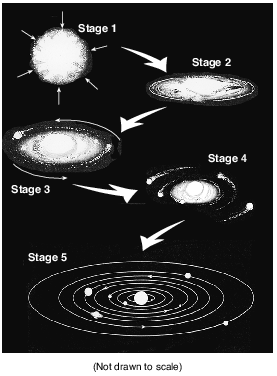
Which process was occurring during some of these stages that resulted in the formation of heavier elements from lighter elements?
(1) conduction
(2) radiation
(3) radioactive decay
(4) nuclear fusion
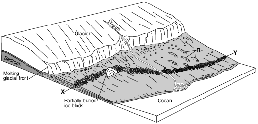
Which feature will most likely form when the partially buried ice block melts?
(1) drumlin
(2) moraine
(3) kettle lake
(4) finger lake
The direction of movement of the major surface ocean currents is most affected by Earth’s
(1) tilted axis
(2) prevailing winds
(3) rate of revolution
(4) tidal action
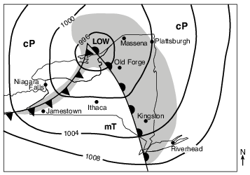
Identify the location labeled on the map that will next experience a short burst of heavy precipitation, a change in wind direction, and a rapid decrease in temperature. [1]
Allow 1 credit for Jamestown.

Identify the name of the depositional feature surrounding location A that is forming where the river enters the ocean. [1]
Allow 1 credit for delta or river delta.
Frozen Mammoth
A wooly mammoth was found in 1999 buried in the frozen soil of the Siberian tundra. Carbon-14 dating indicated that it had died about 20,000 years ago. Many fossils represent only the partial remains of organisms. However, a complete mammoth with bones, skin, hair, and internal organs intact represented a unique opportunity for scientists to investigate the lifestyle of this animal and the environment in which it lived.
The low permeability of the tundra soil helped to preserve the mammoth. Explain why the tundra soil has a low permeability. [1]
Allow 1 credit. Acceptable responses include, but are not limited to:
• — The rate at which water infiltrates the soil will decrease if the soil is frozen.
• — Frozen ground is mostly impermeable.
• — Ice fills the pore spaces.
• — The ground is frozen.
• — The soil is composed of small particles.
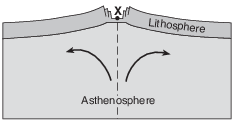
The Great Rift Valley
Rifting of Earth’s crust in eastern Africa began during the Neogene Period as the Ethiopian and Kenyan Domes formed. These two huge domes were created as Earth’s mantle pushed up the overlying crust. As the crust was forced upward, the resulting tension cracked the crust, resulting in the eruption of volcanoes and the formation of large rifts. The crust continued to pull apart, forming rift valleys. These valleys have become deeper and are currently becoming filled with sediments, igneous rock, and water.
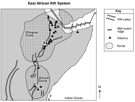
On the cross section in the image provided, draw two curved arrows, one on each side of the dashed line, to show the direction of movement of the convection currents within the asthenosphere that caused the formation of the dome and the rift valley near location X. [1]
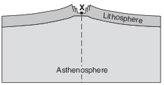
Allow 1 credit for correctly drawn arrows that rise and curve away from the dashed line.
• Example of a 1-credit response:
• 
Explain how the contour lines indicate the direction of flow of Otter Creek. [1]
Allow 1 credit. Acceptable responses include, but are not limited to:
• — Contour lines bend upstream forming a V-shape.
• — Streams flow from higher-elevation isolines to lower-elevation isolines.
• — Isolines bend uphill when they cross streams.
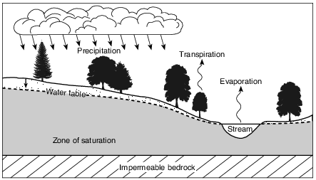
State the relationship between the amount of precipitation in this area and the height of the water table above the impermeable bedrock. [1]
Allow 1 credit. Acceptable responses include, but are not limited to:
• — When precipitation increases, the water table will rise (or get closer to the surface).
• — The level of the water table above the bedrock will increase with greater precipitation.
• — Less precipitation will cause a lower water table.
• — There is a direct relationship between the amount of precipitation and the height of the
• water table above the impermeable bedrock.

Identify which point, X or Y, has more stream erosion and explain why the amounts of erosion are different. [1]
Point:
Explanation:
Allow 1 credit for X and a correct explanation. Acceptable explanations include, but are not limited to:
• — Point X is on the outside of a meander curve.
• — Stream velocity is greater at point X.
• — More deposition occurs at Y.